Esri EADP19-001 ArcGIS Desktop Professional 19-001 Online Training
Esri EADP19-001 Online Training
The questions for EADP19-001 were last updated at Apr 27,2025.
- Exam Code: EADP19-001
- Exam Name: ArcGIS Desktop Professional 19-001
- Certification Provider: Esri
- Latest update: Apr 27,2025
The ArcGIS user is given data for the Arctic and is asked to perform various types of analysis using the data. The data extends from the North Pole south to 70 degrees North Latitude Data layers may contain points lines, or polygons, and include ice surveys from NOAA depth contours: continental margins, locations of known and suspected oil reserves, endangered species habitat, and territorial boundaries for nations having Arctic coastline.
Which map projection should be used for the data to allow the most accurate buffering of those areas, in order to comply with the U.S court decision that ships may not approach closer than 20 nautical miles to a seal rookery?
- A . azimuthai equidistant
- B . polar stereographic
- C . gnomonic
- D . Lambert azimuthal
Using the Spatial Analyst IDW (Inverse Distance Weighted) tool an ArcGlS user interpolates a point feature class to a raster. The user notices that some high point values near the edge of the feature class seem to have a dramatic effect on the output.
This occurs even in areas that are far from the high edge values
Which two parameters should the user consider changing in the IDW tool? (Choose two)
- A . z-value field
- B . search radius
- C . power
- D . output cell size
- E . weight
An ArcGIS user is creating a script tool to automate a common workflow.
Which tool property ensures that the tool only recognizes intended feature data sources?
- A . output spatial reference property
- B . data type fitter property
- C . workspace data property
- D . data extent property
When designing a geometric network where should the feature classes be stored?
- A . inside a single feature dataset
- B . outside a feature dataset
- C . inside any feature datasets sharing the same spatial reference
- D . inside a topology
In the value for the latitude of origin in a projection tile is modified, making the value less negative (e.g. from -45 to -28).
Which way does the data move?
- A . north
- B . south
- C . east
- D . west
An analyst has a multi band raster, but needs just one of the bands for a project.
Which geoprocessing tool should be used to extract a single band?
- A . Slice (3D Analyst)
- B . Extract by Attributes (Spatial Analyst)
- C . Composite Bands (Data Management)
- D . Clip (Data Management)
Refer to the exhibit.
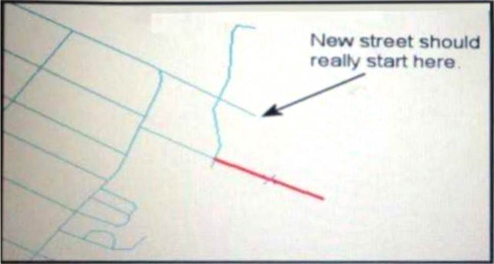
An ArcGIS user added a new street (shown in the exhibit) to a streets feature class within an edit session.
The new street seems to have snapped to an existing street but upon zooming in the ArcGIS user notices that the street is connected to the wrong street.
What is the most likely reason for this error?
- A . The street was digitized at a scale that was too small
- B . The street was digitized at a scale that was too large
- C . The snapping tolerance was set to Low
- D . Edge snapping was turned on Instead of end snapping
An ArcGIS user needs to create a map of flood zones for an insurance company.
The user has a choice of four elevation data sets to perform the analysis
• SRTM 90-meter DEM
• Lidar 5-meter DEM
• 30-meter DEM derived from stereo imagery
Which type of elevation dataset will create the most accurate flood zones?
- A . USGS 30-meter DEM
- B . USGS 30 meter DEM
- C . SRTM 90 meter DEM
- D . Lidar5-meter DEM
- E . 30-meter DEM derived from stereo imagery
An ArcGis user is making a small-scale map using road data that was collected at a large scale.
What is the appropriate tool for removing some of the road detail?
- A . Thin Road Network
- B . Simplify Line
- C . Collapse Dual Lines to Centerline
- D . Smooth Line
An ArcGIS user needs to classify 25 different vegetation types. The user has a single band.
20- meter resolution image with 10-meter spatial accuracy.
Which type of accuracy is the data lacking?
- A . Horizontal
- B . Spectral
- C . Vertical
- D . Spatial
Latest EADP19-001 Dumps Valid Version with 93 Q&As
Latest And Valid Q&A | Instant Download | Once Fail, Full Refund
