Esri EADP19-001 ArcGIS Desktop Professional 19-001 Online Training
Esri EADP19-001 Online Training
The questions for EADP19-001 were last updated at Dec 14,2025.
- Exam Code: EADP19-001
- Exam Name: ArcGIS Desktop Professional 19-001
- Certification Provider: Esri
- Latest update: Dec 14,2025
An ArcGIS user wants to create a hierarchy and differentiate cities on a map by categorizing the way the features are labeled.
What should be used to achieve the desired result?
- A . label expressions
- B . label classes
- C . label stacking
- D . label priority
Four emergency response facilities need to be placed so that the greatest number of people in a community can be reached within five minutes.
Which analysis method is used to make this determination?
- A . location allocation
- B . closest facility
- C . route
- D . Dufer
In a disconnected environment a data receiver fails to send acknowledgement messages often enough.
How will the data sender respond?
- A . Resends change messages
- B . sends the next change messages
- C . Slops sending change messages
- D . Discards the change messages
When is an ArcGlS user required to change the format of data before working with it in ArcMap?
- A . when the data is an ESRI interchange (.e00) file
- B . when the data is an Autodesk dwg file
- C . when the data is an ERDAS Imagine (img) file
- D . when the data is in a JPEG (jpg) format
An ArcGIS user is making a map and needs to symbolize cliff and escarpment features above contour features.
How can the features be ordered correctly if they are all in the same layer?
- A . set a definition query
- B . use symbol level drawing
- C . use scale-dependent drawing
- D . reorder the symbols in the symbology properties
After the ground water is the local community was contaminated by a landfill, the health department requested a map showing the cancer rate for each postal code. An ArcGlS user Is provided a file geodatabase feature class (FeatureClassA) that has been joined to a cancer rate table (TableB). The cancer rate table does not have data for each postal code In the study and also contains data outside the study area creating null values. To eliminate the null values from being symbolized.
Which exclusion query should be used?
- A . (FeatureClassA OBJECTED is Not Null) and (TableB.cancerrate Is Not Null)
- B . ("FeatureClassA OBJECTED" is Not Null) and (TableB.cancerrate is Not Null)
- C . ("FeatureClassA OBJECTED". "TableB cancerrate" is Not Null)
- D . ("FeatureClassA OBJECTED" and "TableB cancerrate" is Not Null)
An ArcGIS user processes a point feature class using the Collect Events tool. The user finds that the output value for each feature is 1.
Why did the tool only produce values of 1?
- A . NONE of the points are co-located
- B . mere is only one event to collect
- C . All points are within a standard distance of one other point
- D . The total value of all events adds up to 1
An ArcGIS user wants to make a map displaying the data using an equal number of features in each classification.
Which classification method should the user employ to accomplish this?
- A . equal Interval
- B . natural breaks (Jenks)
- C . quantile
- D . standard deviation
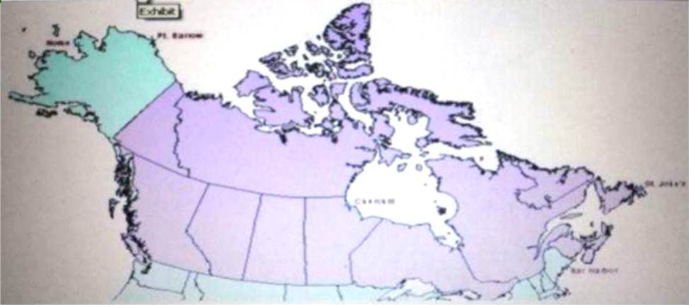
Refer to the exhibit.

The ArcGIS user is given data for the Arctic, and is asked to perform various types of analysis using the data. The data extends from the North Pole south to 55 degrees North Latitude Data layers may contain points lines, or polygons and include ice surveys from NOAA depth contours; continental margins, locations of known and suspected oil reserves, endangered species habitat and territorial boundaries for nations having Arctic coastline.
An ArcGIS user is asked to calculate the distance a cruise ship will travel through open water, departing from Nome, Alaska, with stops at Point Barrow Alaska Churchill Manitoba St John’s Newfoundland and ending in Bar Harbor Maine. On the basis of these calculations the cruise ship line will determine fuel requirements and travel time.
Which map projection yields the most accurate results for this distance calculation?
- A . Albers equal area conic
- B . Lambert azimuthal
- C . Mercator
- D . azimuthal equidistant
When is an ArcGIS user required to convert a triangulated irregular network (TIN) surface of elevation to a raster?
- A . when generating contours
- B . when extracting slope information
- C . when creating the steepest path
- D . when performing map algebra
Latest EADP19-001 Dumps Valid Version with 93 Q&As
Latest And Valid Q&A | Instant Download | Once Fail, Full Refund

